

How to Accurately Forecast Surf on the Great Lakes
I know way too many Great Lakes surfers who have rocked up at their favorite surf spot full of hope and been totally let down by what they’re looking at.
I’ve certainly had my fair share of long drives for disappointing waves, that’s for sure.
Which is frustrating, because we don’t get that many great days of waves on the Lakes in the first place!
So a year ago, I decided to start devising a system to reliably forecast the Lakes and ensure I didn’t waste the opportunities we do get.
What I discovered through my trial and error was that there absolutely is a repeatable process for forecasting surf on the Lakes with near perfect accuracy.
In fact, it’s actually way simpler than forecasting the ocean when you know what to look for.
Why forecasting the Lakes is very different than forecasting the Ocean
One of the things that trips a lot of people up when forecasting the Lakes is how differently waves actually form on the Lakes when compared to the ocean.
I’m going to attempt to explain this without getting too deep in the meteorological details, so stick with me for a second here.
Most ocean swells are generally formed far away from where you actually surf them.
For example, waves that hit Hawaii and California are created from storms that form off the coast of Japan or Russia and work their way across the North Pacific before pushing down and arriving at breaks like Pipeline or Rincon.
Then, when the swell arrives, you’re checking the local weather report to see when the wind is best to surf that swell.
This means that when you’re forecasting surf in the ocean, you’re actually forecasting two things simultaneously: the swell itself and the local wind/weather conditions when the swell arrives.
On the Lakes, however, swells don't have enough space to separate from the storms that create them. There just isn’t enough fetch (the distance wind travels over open water to create waves) to create waves big enough to surf independently of where you’ll surf them.
As a result, waves are always created in the direction that the wind is blowing, instead of separately from it like the ocean.
Why this matters for forecasting surf on the Lakes
Because waves always follow local wind patterns on the Lakes, to accurately forecast surf, you actually need to forecast the wind/weather, not the waves.
This is why I say forecasting surf on the lakes is actually simpler than the ocean when you know what to look for.
Since weather and waves are linked, you only have to focus on getting the weather/wind forecast right to figure out where the waves will be (vs weather and swell and tide on the ocean).
One caveat to this statement is that because waves are linked to weather on the lakes, you really can’t forecast surf on the Lakes more than 72 hrs in advance with any kind of precision.
Most weather forecasts are only ~90% accurate at the 3 day mark and become less reliable the further out you are. So trying to predict exactly what the surf will do at your local spot outside of this window is a coin flip at best.
To forecast the Lakes accurately, use one of these free tools, not Surfline
Since surf on the Lakes is directly linked to local weather patterns, the best way to forecast surf accurately is by using local weather and wind tools.
I’ll go into greater detail as to why Surfline is not the best choice for the lakes down below, plus how to hack it to get a decent forecast if you’re hellbent on using it. But the quick explanation is that its modeling is actually overkill for getting a reliable surf forecast on the Lakes.
Let's talk about the tools I do recommend first and how I use them (they’re all free).
Tool #1: NOAA’s GLERL Wave Watch III Model
The number one tool I always recommend to people (and the first tool I always look at when forecasting surf on the Lakes) is the National Oceanic and Atmospheric Administration’s Great Lakes Environmental Research Laboratory Wave Watch Model III.
Yeah, it’s a mouthful. And the tool is clunky. But it works.
GLERL gives you a 3-day overview forecast of the waves across all of the lakes that is based on wind patterns. You can select individual lakes, or look at the overview of all of the lakes to see what to expect over the next 3 days:
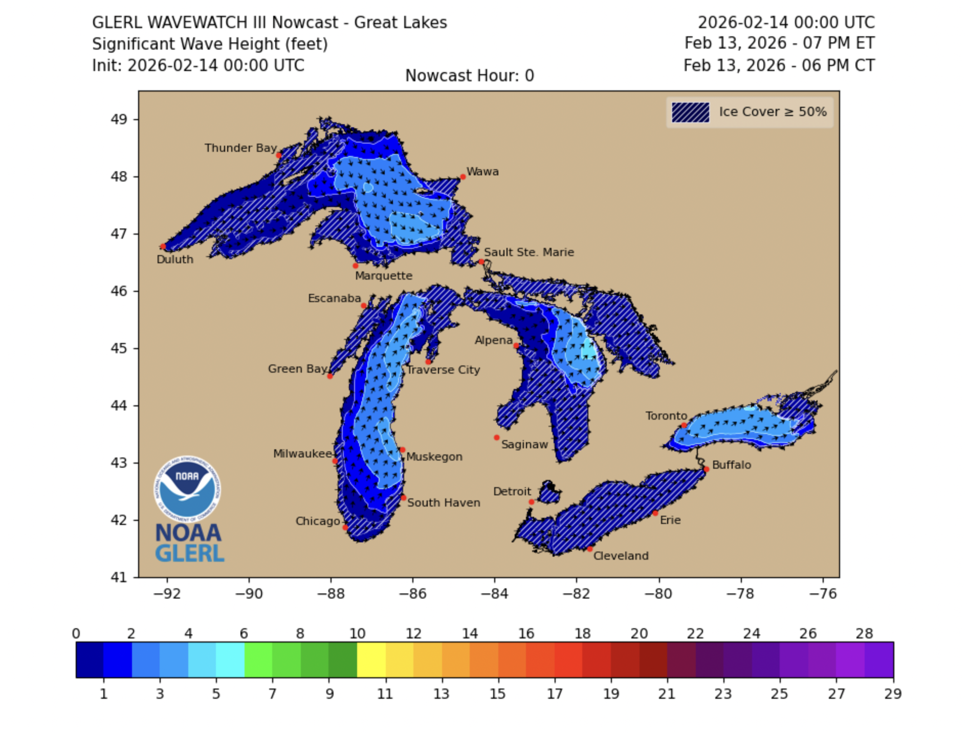
I always look at GLERL 72 hrs in advance to see if there is any swell on the horizon. If there is, I check GLERL for the next 2 days to track any changes (there usually are).
During peak Lake surf season, I always have GLERL open on my phone.
Tool #2: Windfinder
Windfinder gives you a 7-day forecast including wind, swell period, and swell size for various spots around the lake. It also has webcams/photos for certain spots around the lakes as well, totally free.
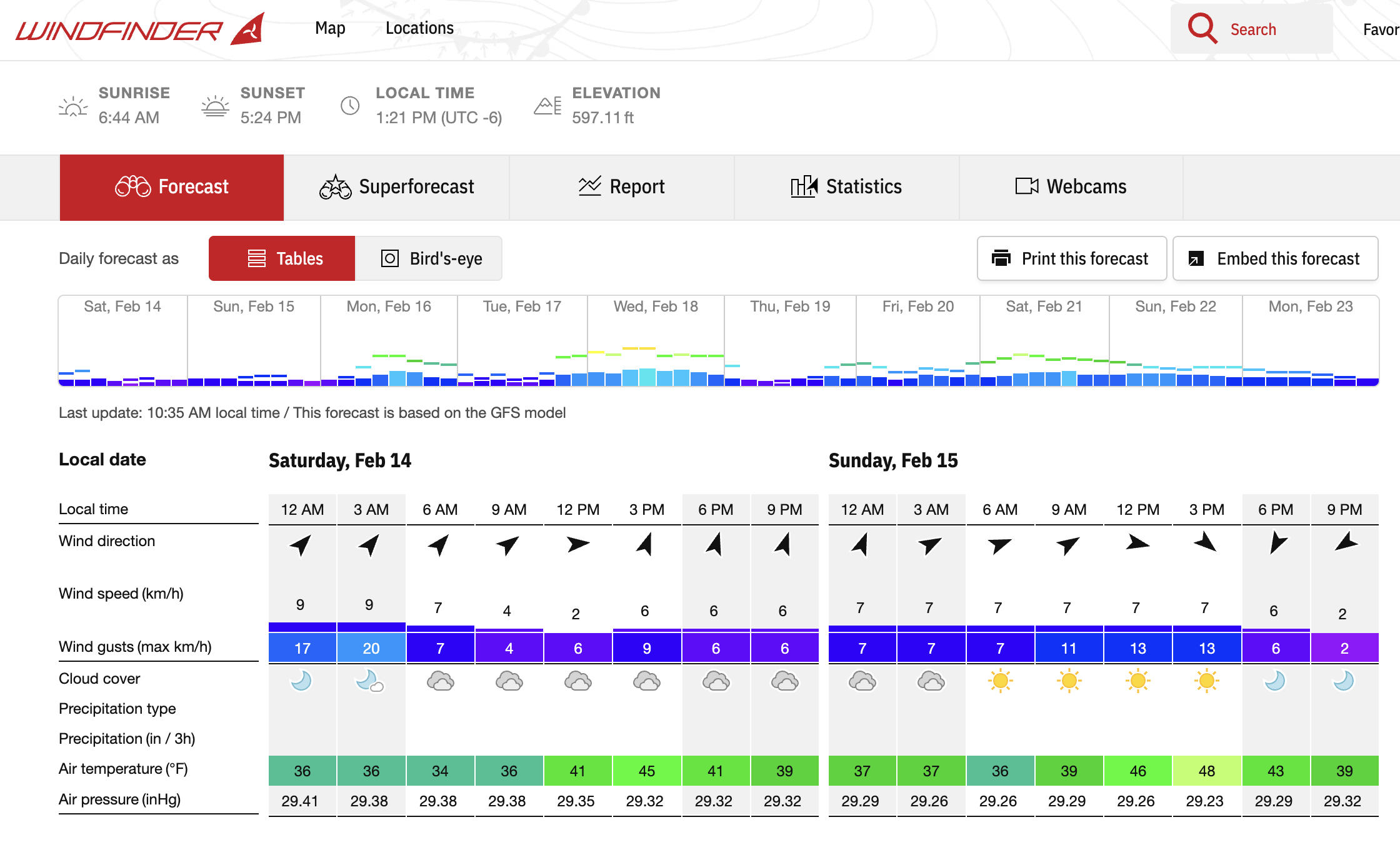
Note: Windfinder shows swell data on their mobile app.
I use Windfinder to get local swell data that GLERL does not provide.
GLERL is great for an overview, but it doesn’t let you see what the swell will be doing at a particular spot. So Windfinder bridges that gap and helps me understand what to expect at the spot I’m planning to surf.
It’s worth noting that Windfinder’s data model is built on the same model as GLERL (WaveWatch III).
It’s also worth noting that the swell data it provides is interpolated, not actual buoy data. So the numbers you’re seeing are an educated guess, not a real measurement.
However, Windfinder’s data is the closest thing I’ve found to actual swell data on the lakes, so it provides a solid foundation for you to start tracking how different swells work at your favorite spots.
You can download the Windfinder Mobile App for iOS here and Android here.
Tool #3: Windy
Windy is another great app similar to Windfinder. It was the tool I used most often before I found Windfinder and I still check it regularly to get a sense of what the wind will be doing at the specific spot I want to surf (either the night before or the morning of).
What I like about Windy is the ability to see the angle of the wind and how it will likely change throughout the day at the exact spot I’m surfing.
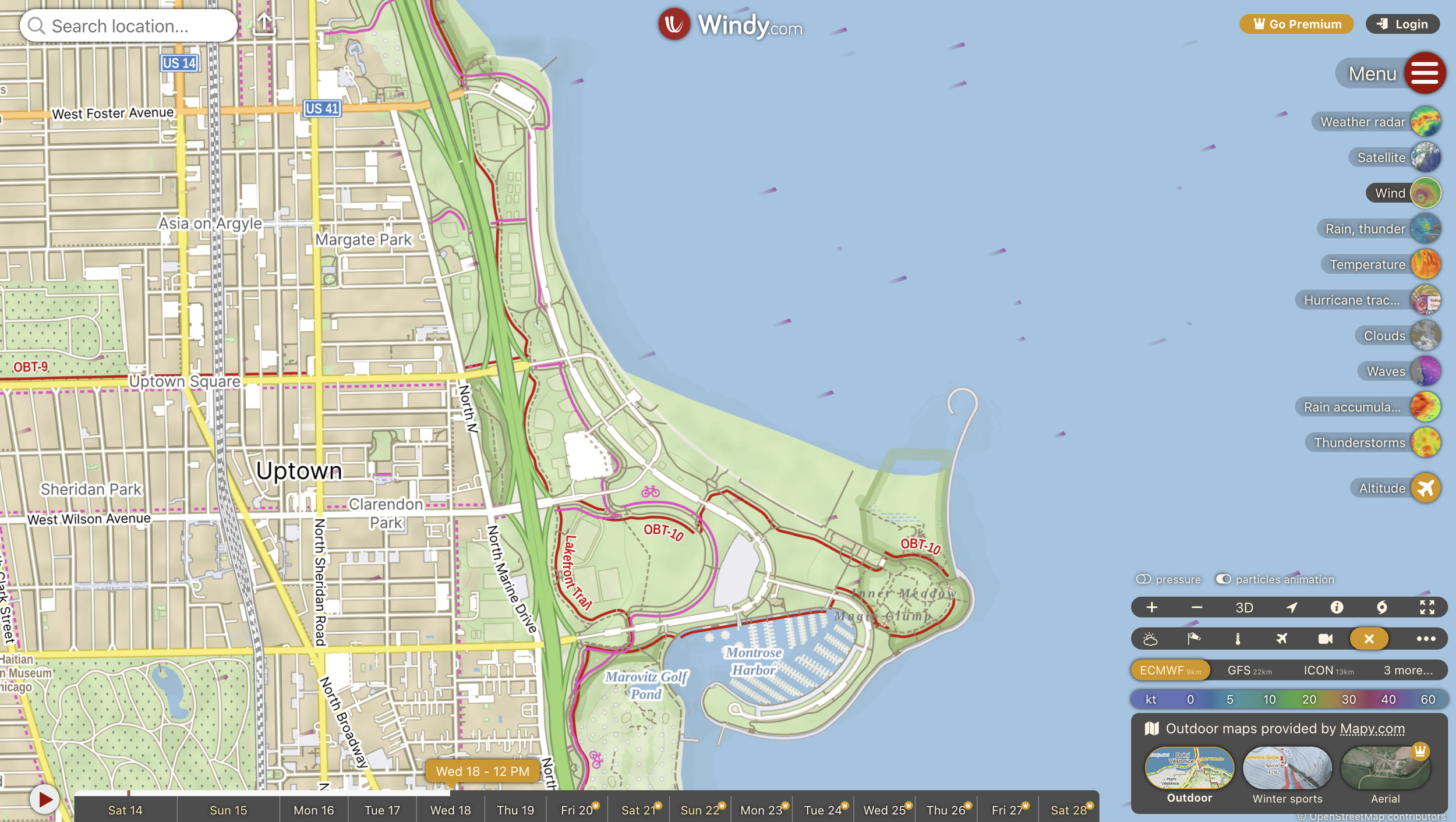
Using this data combined with swell data from Windfinder and GLERL, I can see when swells will peak and also if the wind will shift at all throughout my session.
Another reason I still check Windy in addition to the other two tools is because it uses different models than GLERL and Windfinder.
This gives me another data point for confirming my forecast. And more data means less likelihood of getting skunked.
You can download the Windy mobile app for iOS here and Android here.
Why I don’t recommend Surfline
The main reason I don’t use Surfline is that it’s just not as accurate as the tools above.
To be completely honest, I’m not totally sure why this is the case. But from what I can see (and from what I’ve experienced), I think their modeling is actually too complex for the Lakes.
Without getting into the specifics of the data modeling that Surfline does, the main thing to know is that it’s built on Surfline’s proprietary LOTUS model, which layers some special bathymetry mojo on top of NOAA’s WaveWatch III (what GLERL uses).
You can read about it here if you want.
In theory, this means Surfline should work great for the Lakes. But in practice, I think the other stuff they’re doing to try to model waves actually creates misleading forecasts.
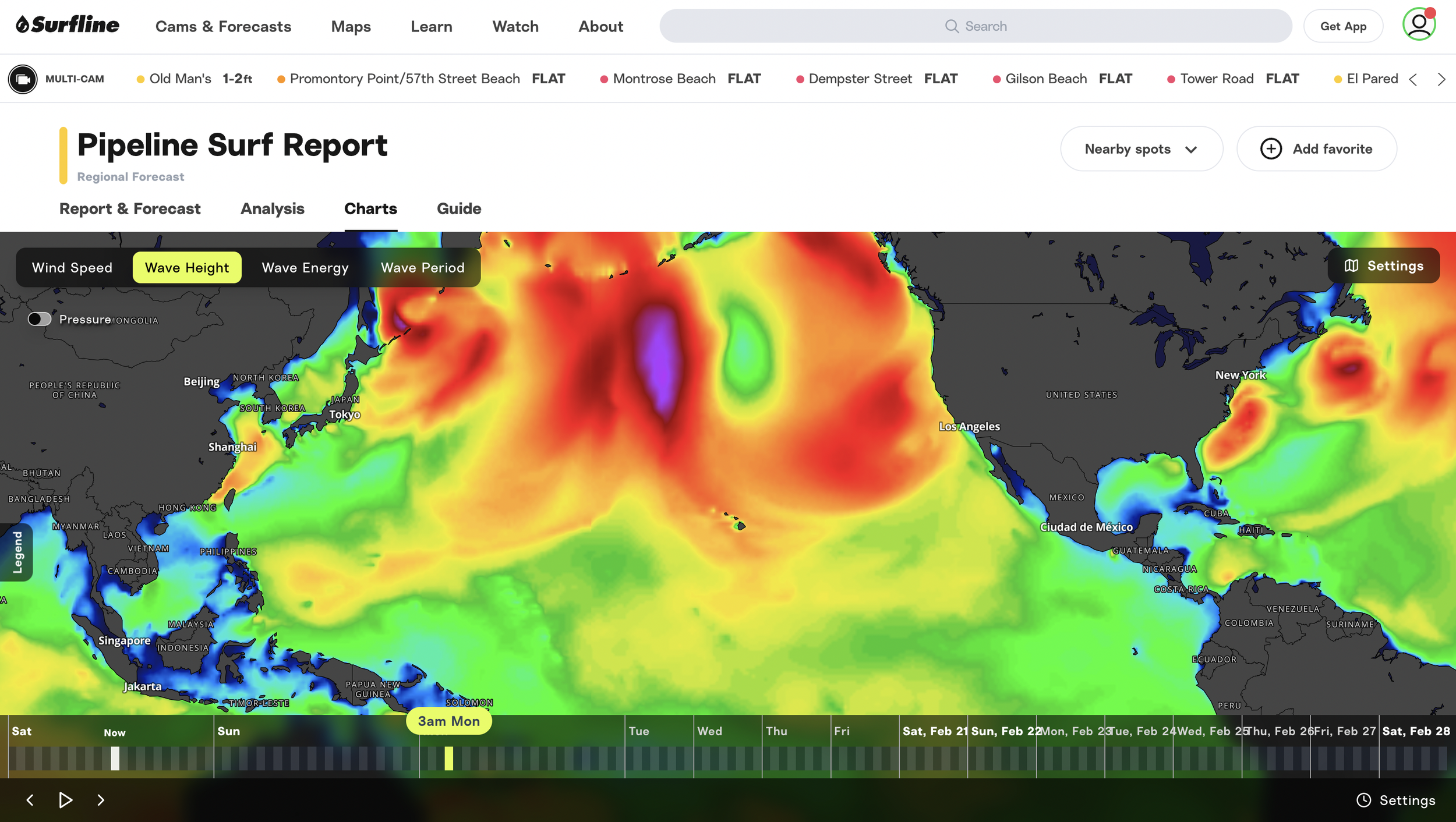
Here’s an example:
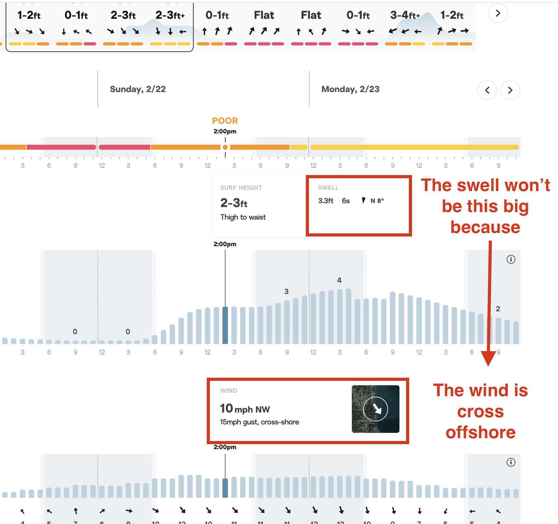
As you can see here, Surfline shows 2-3ft at this spot in Chicago. But the primary wind direction is showing cross-offshore.
Since the swell always follows the wind direction, this forecast means the best waves would actually be in Indiana/Michigan on this day.
So if you were to make a decision to surf this particular spot based on Surfline’s swell data, you’d end up surfing tiny waves at best, because the wind is blowing away from the beach.
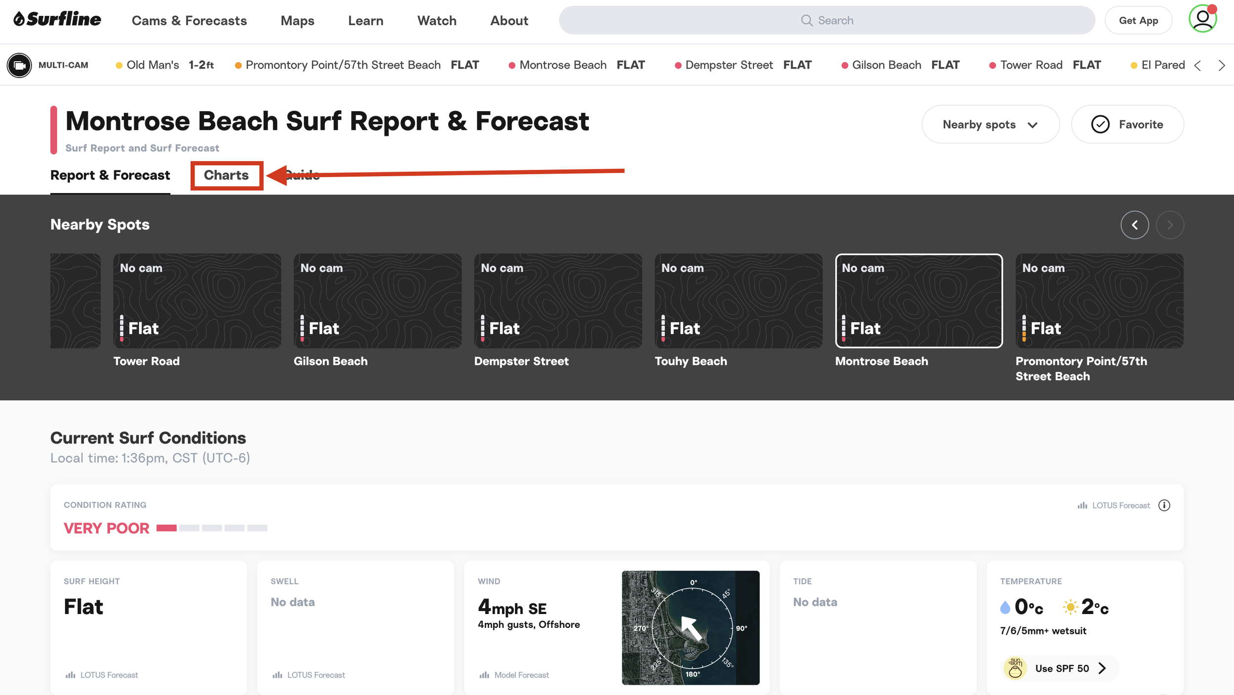
How to hack Surfline to get a decent forecast
If you insist on using Surfline to forecast the Lakes, here’s how to do it.
First, completely ignore the data shown in the surf spot overview except for the wind for reasons mentioned above.
Instead, inside the surf spot report, go to the “Charts” menu.
Then select “Wind Speed” to display the wind modeling.
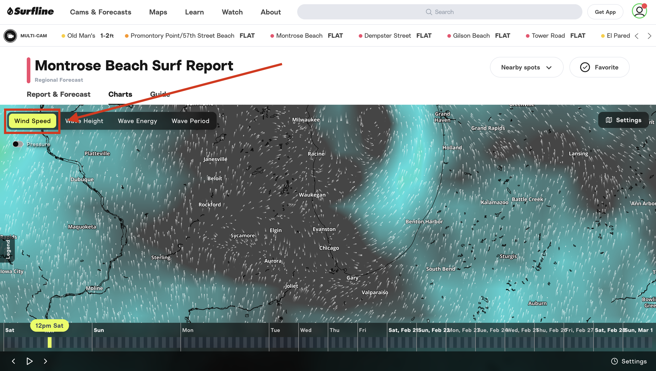
Finally, zoom in and check the spot on the lake you want to surf with the direction of the wind. This will give you a decent approximation of what the wind is doing on the lake and what to expect around the spot you want to surf.
Track this data to pick the best surf spot on any given day
If you want to start forecasting any surf spot accurately, you have to be a student of the data.
On the lake, the data I use for forecasting is quite a bit different than what I would use to forecast the ocean.
Here is what I track.
Wind Angle
Since swells on the Lakes always arrive at the beach that is downwind, wind angle is the most important data point to consider if you’re trying to figure out whether your surf spot will have waves or not.
If the primary wind direction is even slightly offshore relative to your spot, you’re not going to get much in the way of waves.
So when I’m checking the forecast for a session, wind angle is the very first thing I look at.
I always start by checking GLERL for the primary wind direction and then try to find a spot that is angled 45°-90° to that swell direction (and protected if I can find it) so it’s not fully onshore where I plan to paddle out.
Then I check Windy to see what the wind will most likely do throughout the session (and hope that I can find a spot where the wind goes offshore at some point).
Wind Speed
After wind direction, the next data point I track is wind speed. The harder the wind blows, the bigger the waves. Simple as that.
I usually start by getting an overview in GLERL when I’m checking the wind direction for the swell. The more yellow/orange/red the graphs go, the more power there will be in the water.
Then I cross reference this in Windfinder to see how the wind will translate into things like swell size and swell period at the spots I’m considering.
In both of these tools, I’m also looking at how long the wind maintains that speed in one direction.
A swell that is generated from wind blowing at 25mph for 2 days in the same direction will have a lot more size and power than a swell that is generated from wind that blows at 25mph for 24hrs hours in one direction and then 24hrs in another.
Temperature Change
Another great indicator that a solid swell is on the horizon is a big temperature drop. If you look at your weather app and see a big temperature drop happening overnight plus favorable winds, you’ll probably get good waves.
The science behind this is complicated, but all you need to know is that cold air creates bigger waves because it transfers energy into the surface of the water far more efficiently than warm air.
This is why groundswells that hit Hawaii and California are always created closer to the poles instead of being formed locally (the exception here is hurricanes of course).
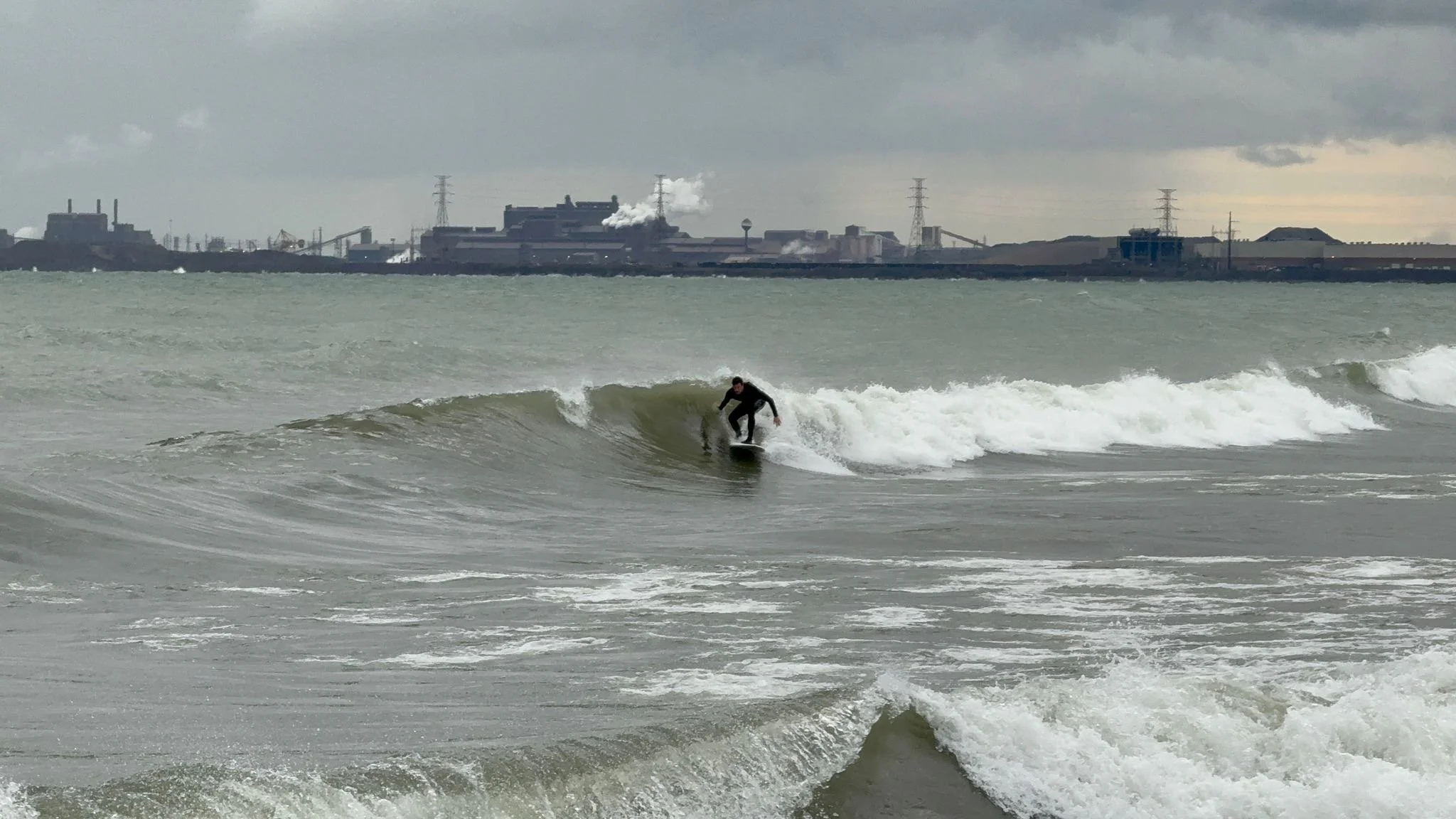
It’s also the reason why the prime lake surfing season is the Fall (cold air over warm water) and some of the best swells on the Lakes happen in the dead of winter (ultra cold air).
Using buoys to forecast
For parts of the year, there are a few buoys in the Lakes that can give you an estimate of what the swell is doing in real time.
These are useful for getting day-of data (i.e. before you drive 2 hrs) but you can’t use them in isolation. You have to consider wind/swell angle in relation to where these buoys are placed, otherwise you might still show up and get skunked.
I don’t even bother to look at the buoys anymore. There aren’t enough of them and they’re in the wrong place for predicting surf at the spots I frequent most often, so I stick to the tools above.
Forecast the wind, not the waves.
If there is one thing you should take away from this article, it’s this: on the lake, waves always follow the wind.
If you can accurately forecast wind direction and speed, you can more or less eliminate the chance that you’ll ever get skunked again.
The tools I’ve listed here are built on wind models and are designed exactly for this purpose. So while you can use Surfline, I promise you’ll have better luck using one of those instead.
A quick note: I wrote this article to be a resource for the lake surfing community. So if you have anything you think might be worth adding to it that you think I’ve missed, please reach out.